| Projects |
|
|
The GEOMAGIA50 database currently stores 8702 archeo and
paleomagnetic and paleointensity determinations dated to the past 50000 years.
It also stores details of the measurement setup for each determination,
which are used for ranking the data according to prescribed reliability criteria.
The ranking system aims to alleviate the data reliability problem
inherent in this kind of data.
GEOMAGIA50 is based on two popular open source technologies.
The MySQL database management system is used for storing the data,
whereas the functionality and user interface are provided by server-side
PHP scripts. A plotting feature is also available to display data. It was implemented using Generic Mapping Tools and Python.
|
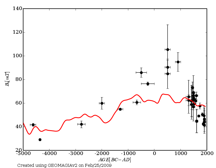
Example of GEOMAGIA50 output: the geomagnetic field intensity in Finland. Black dots represent archaeological data, and
red line is the CALS7k.2 model.
|
We created five new time varying spherical harmonics models using selection of archeological data and lake sediments.
The five selections are available from the EarthRef Digital Archive (ERDA).
Data were grouped according to the source of material, and we conducted separate assessments of reliability for archeomagnetic artifacts and lava flow.
We discuss relative merits of a larger unconstrained dataset or a smaller (possibly) more reliable one. The constrained data sets eliminate a priori up to 34% of the available data in each case,
and rely on potentially subjective assessments of data quality. Given the limited data available our analyses indicate that iterative
rejection of a small number (1-1.5%) of outlying data during global field modeling is a preferable approach.
Specific regional comparisons among the models and data support the conclusion that outlier free CALS3k.3 model based on all available measurements
from sediments and archeological artifacts currently provides the best global representation of the 0-3ka field and the archeological articfacts only model
provides a better fit to the dense European archeomagnetic data and may be better in that region.
|
|
Movie showing the geomagnetic field intensity during the past 3000 years, based on the CALS3k.3 model.
Gray circles represent the location of the data.
|
Participating scientists
- Fabio Donadini
- Lisa Kapper
- Ann Hirt
- Diego Angelucci (Univ. degli Studi di Trento, Italy)
- Annaluisa Pedrotti (Univ. degli Studi di Trento, Italy)
- Michel Mauvilly (Amt für Archaeologie des Kantons Freiburg, Switzerland)
Project goals
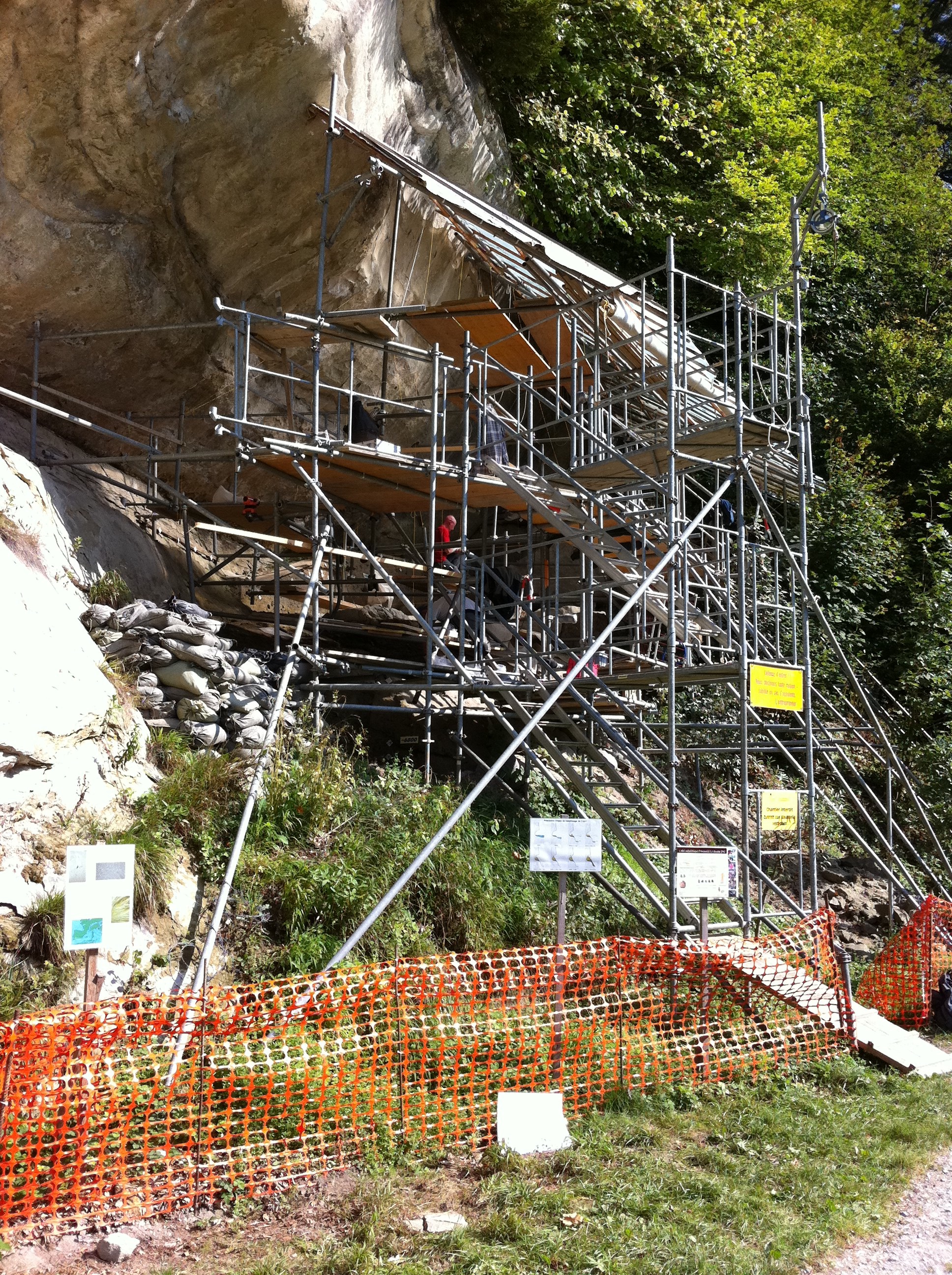
This project aims at providing new Alpine archeomagnetic data that will cover periods between 7000 BC and 1500 AD. At present two sites are under investigation: the Gaban shelter close to Trento, and the Arconciel shelter near Fribourg.
We determine directions and intensities from burnt anthropogenic sediments and artifacts of the Mesolithic and the Neolithic, as well as of the Eneolithic (Copper Age).
Directions will be directly compared with lake sediment data, whereas intensities will be used to calibrate the relative intensities from the lake cores.
Characterization of the rock magnetic properties of these features will be performed to investigate the origin (e.g. firing conditions) and the stability of the magnetization.
Reciprocally archeomagnetic dating will be useful for archeologists, who are contributing material.
Sites investigated
 |
 |
| During the Mesolithic period hunters continuosly occupied the Arconciel shelter. Several layers of burnt sediments along the excavated section represent ancient fireplaces and are sampled for archeomagnetic investigations.
|
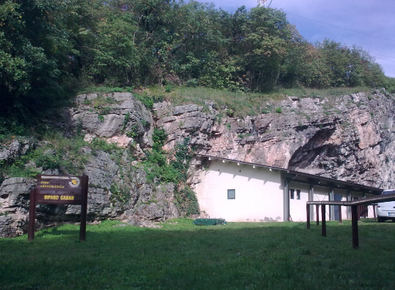
The Riparo Gaban is located near to Trento. This site was also continuosly occupied throughout the Mesolithic through the Neolithic, and after an abandonment phase there are evidences of occupations during the Copper age.
Several burnt anthropogenic sediments from units spanning the Neolithic to the Copper age were sampled for archeomagnetic investigations.
|
Highlights
 |
 |
|
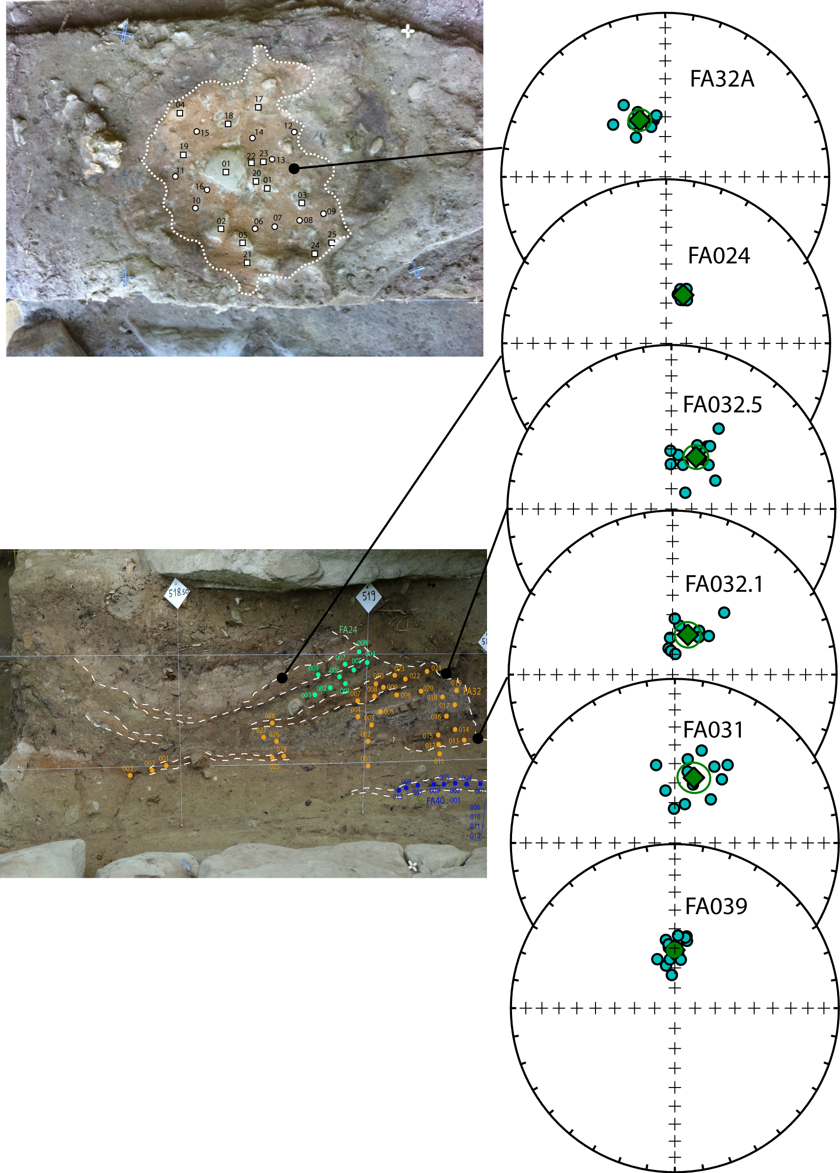
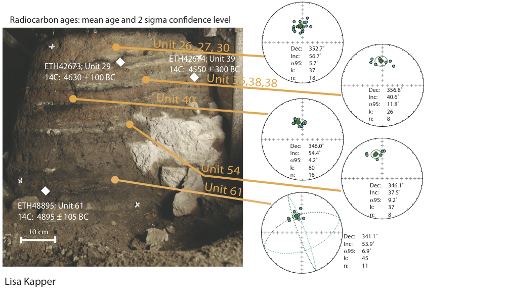
Several foyer from Arconciel were investigated to obtain directions. The stereoplots in the figure above are ordered by stratigraphic sequence.
|
The section 10 at Riparo Gaban consists of a sequence of antropogenic burnt layers and organic layers. Directions obtained from the burnt layers
are shown in the stereoplots on the side.
|
 |
|
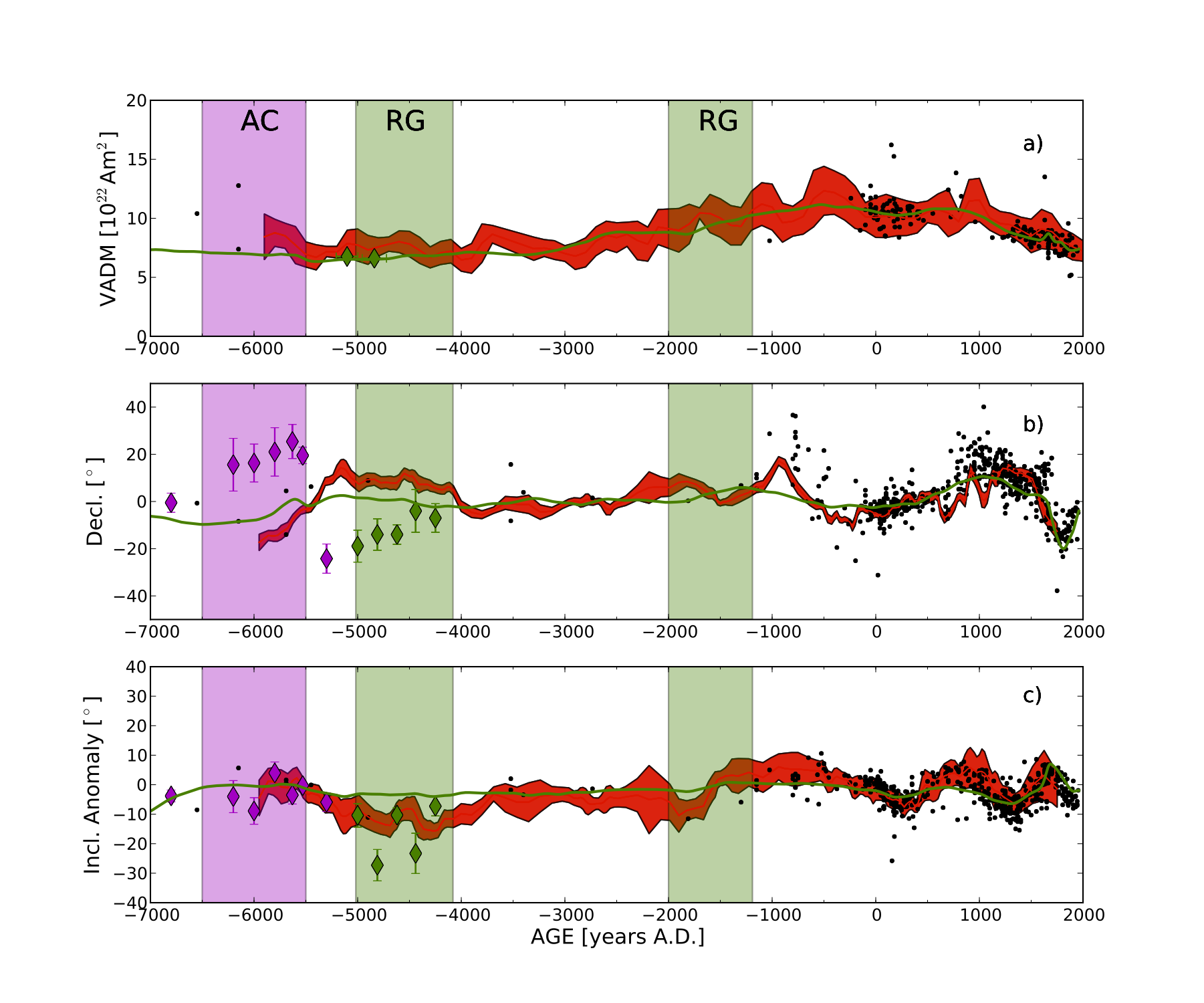
Figure showing the geomagnetic field trends from the measured foyers. Magenta (green) diamonds represent Arconciel (Riparo Gaban) results, , black circles are published archeomagnetic results from a Switzerland, France, and Italy. Intensity (a), Declination (b), and Inclination anomaly (c) are shown.
Red line is the Balkan reference curve (Tema and Kondopoulou, 2011), green line is the CALS10k.1b model (Korte et al., in press).
|
Recent publications
- Kapper, L., Donadini, F., and Hirt., A.M., 2011. Rock- and archeomagnetic characterisations of burnt sediments to investigate the geomagnetic field evolution during the mid-Holocene. Geophysical Research Abstract, 13, EGU2011-9748
- Kapper, L., Donadini, F., and Hirt., A.M., 2011. Rock- and archeomagnetic study on central European artifacts for characterizing the geomagnetic field evolution during mid-Holocene. Abstracts of the 9th Swiss Geoscience Meeting, P6.6, 220-221
References
- Korte, M., Constable, C.G., Donadini, F, and Holme, R., 2011. Reconstructing the Holocene geomagnetic field. Earth and Planetary Science Letters, accepted for publication.
- Tema, E., and Kondopoulou, D., 2011. Secular variation of the Earth’s magnetic field in the Balkan region during the last eight millennia based on archaeomagnetic data. Geophysical Journal International, 186, 603-614
Other information
- This project is funded by SNF and the ETHIIRA research programme
|
|